
MapLarge
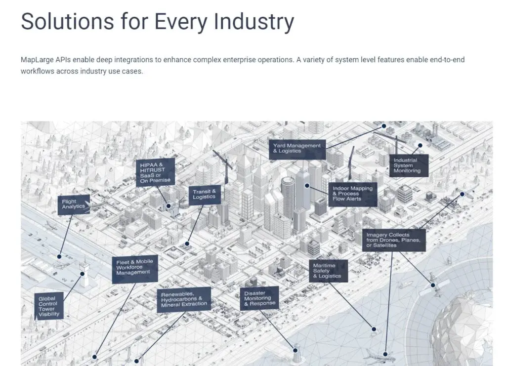
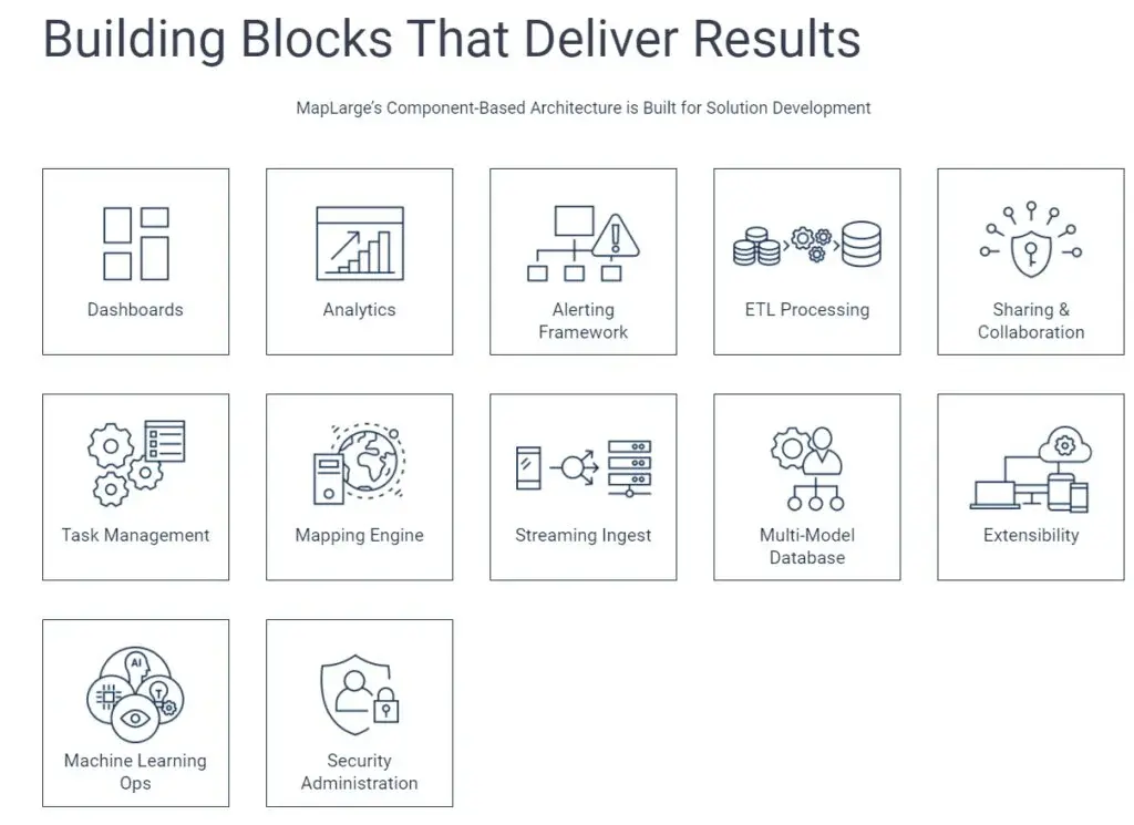
MapLarge is one of the many platforms that gives you access to various tools for creating IoT and Geospatial applications. It faces System design by adopting a Building Block Methodology. You can use several of its APIs to activate deep integrations to optimize sophisticated enterprise operations. Many of its system-level features allow for end-to-end workflows throughout industry use cases.
You can utilize the Analytics module to uncover valuable data and check progress. It requires little configuration, resulting in the saving of time and effort. The platform implements an advanced distributed column store, and thanks to this, it can take advantage of several indexes and data representation within one table.
Other benefits associated with this module include extending model functionalities to fit new use cases and sources and querying big data stores for discovery. The features don’t stop at Analytics, and there are many more tools available for you, such as Security Administration, Task Management, Extensibility, Machine Learning Ops, ETL Processing, Dashboards, Streaming Ingest, Mapping Engine, and Multi-Model Database.
MapLarge Alternatives
#1 Maptitude
Maptitude is a Geographic Information system solution developed by Calliper to help you find the exact location of customers, solve geographic queries that impact your business, identify the highest sales areas, unlock concealed opportunities, and visualize geographic trends and patterns that can’t be viewed in spreadsheets and database tables.
The software provides you with the maps, tools, and demographic data required to scan and comprehend how geography impacts your operations. Maptitude understands the concerns and difficulties faced by customers every day and therefore has added every feature to assist them in overcoming modern-day challenges and making a name for themselves in the industry.
It offers extensive desktop mapping functionality and comes with the latest and optimized features to enable the customer to create new maps and edit them with great ease. The highlights include Measuring distances and identifying shortest and fastest routes, calculating distance or drive-time rings at the desired interval, creating custom territories for mini areas, and discovering trade areas, and finding profitable sites.
#2 ArcGIS Pro

ArcGIS Pro is a comprehensive and favorite GIS software of many people worldwide. It is a standalone desktop GIS application and is bundled with many tools to help you with your needs. It is developed with improvements and tips gathered from the user community. The solution supports authoritative data maintenance, data visualization, and advanced analysis in 2D, 3D, and 4D.
Users can take advantage of its data-sharing capabilities to transfer data between multiple products such as ArcGIS Enterprise and ArcGIS Online. This allows everyone to use Web GIS to work across the ArcGIS system. You can turn data into meaningful and reliable information by mixing several data sources to transform maps that are both amazing and intuitive.
Solve problems, find patterns, and make predictions by using its highly advanced scientific analytical tools on 2D, 3D, and 4D data. Share your work and data within multiple departments of the organization via mobile apps or online. The key strengths of ArcGIS Pro include Exploration and Visualization, Launching new Capabilities, Cartography and Design, Customize ad Create, Analytics and Data Science, Imagery, and Data Management.
#3 PostGIS

PostGIS is a simple and open-source spatial database extender for PostgreSQL released under the GNU General Public License that allows you to run location queries in SQL. It comes packed with many features like basic location awareness and many more that are not offered by prominent databases like SQL Server and Oracle Locator/Spatial. One of the major highlights is that it is capable of rendering raster data in several standard formats like NetCDF, GeoTIFF, JPG, PNG through SQL.
It provides a packaged command line to help you import raster data in various formats, including JPG, GeoTiff, PNG, and NetCDF. In addition to these characteristics, PostGIS supports processing and analytic functions for raster as well as vector data for reclassifying, splicing, morphing, dicing, and joining/gathering thanks to the power of SQL.
#4 GPS Visualizer

GPS Visualizer is an online DIY Mapping facility that allows you to create profiles and maps seamlessly by using geographic data. It can be used by anyone with a device having a web browser and connection to the Internet. There are no payment requirements, and you can start using this easy, powerful, and customizable tool without delay.
It recognizes input in the form of basic coordinates, GPS data, street addresses, driving routes, meaning you can only add these for the creation of maps and profiles. You can use the online utility to check recent visits, plan new journeys, or instant see geographic data like geotagged photos, scientific observations, real estate, events, customers, and business locations. Lastly, GPS Visualizer supports multiple file formats for data reading, such as GPS, Suunto X9/X9i, Timex Trainer TomTom, Garmin Forerunner, and Geocaching.com.
#5 Esri ArcGIS
ArcGIS, developed by Esri, is a simple yet powerful solution that comes with competitive capabilities and a fair pricing model to help you implement location-based analytics into your business dealings. Receive valuable insights via contextual functions to view and examine the data and collaborate and share information through reports, maps, dashboards, and apps.
You can connect to the disconnected, and a wide set of spatial algorithms and analytical methods are available. Leverage location as the means to discover concealed patterns, enhance predictive modeling, and transform your business. Use the capabilities of data science and spatial analysis whenever the need be.
Esri ArcGIS offers a great Mapping tool with which you can identify spatial patterns in the data to make the right choices. Maps enable collaboration and put an end to limitations. You can easily create, utilize and share resources with others through the desired device. Other features include Data Collection and Management, 3D GIS, Imagery and Remote Sensing, and Field operations.
#6 ZeeMaps

ZeeMaps is a platform that provides you with the necessary tools to create and publish interactive maps with great ease. The highlights include multiple access levels for each map, such as Admin, Viewer, and Member, and supports input from GeoRSS feed, CrowdSource, Microsoft Excel, KML, Google Spreadsheets, and CSV.
You can create as many maps as desired and use them for presentations and analysis and enjoy some great features. The online utility doesn’t consume your time by enabling you to start right away without having to sign up first. Everyone can customize marker images by adding their own images and restricting map data to private.
The infrastructure is compliant with HIPAA and supports HTTPS. You can manage the whole of map items using its editing grid and add audio, video, photo via markers. The platform is mobile-friendly, allowing for maps to be displayed on portable devices with small screens such as tablets and smartphones. Other key strengths of ZeeMaps include Trip Planner, Spatial Data Aggregates, Traffic Overlay, Heat Maps, Marker Groups, Geo Search, Moderated Additions, and Entry List.
#7 ERDAS IMAGINE

ERDAS IMAGINE is the leading Sensing Software Package liked by many people across the globe. It offers a data authoring system and supplies tools that help you meet Geospatial Analysis, Remote Sensing, and Photogrammetry requirements. The solution is a perfect fit for geographic imaging professionals who have to run bulk geospatial data each day, and for this reason, they end using software that is not made for these tasks, resulting in the creations of many problems.
By using ERDAS IMAGINE, these professionals can save effort, time, and money by taking advantage of available data investments and enhancing their image analysis functionalities. The tool delivers great value and unifies radar processing, remote sensing, basic vector analysis, photogrammetry, and LiDAR analysis in one place.
The solution has powerful data processing functions and algorithms that allow you to focus on analysis without worrying about anything else. It adds ease when working with crucial tasks like image interpretation, image classification, elevation extraction, orthorectification, reprojection, and segmentation. Apart from these characteristics, there are a few more features offered by ERDAS IMAGINE, such as Point Cloud Processing and Power of Spatial Modeler.
#8 Azure Maps

Azure Maps is a set of Geospatial APIs that helps you enrich your apps with spatial analytics, maps, and mobility solutions. You can use this amazing resource to create web and mobile apps that are location-aware by utilizing secure SDKs, geospatial services, and APIs in Azure. It has built-in location intelligence from leading Mobility technology providers such as AccuWeather and TomTom that allows you to offer smooth experiences based on geospatial data.
Integrate mobility and enhanced location functionalities into applications using geospatial services. Azure Maps offers Time Zones functionality to help your users check current time from any place. The audience can search for interesting locations nearby and use addresses to get relevant latitude/longitude coordinates using the search feature.
You can provide the fastest and shortest routes possible to various destinations or specialized facts and routes for commercial vehicles, walkers, and bicyclists. Use batch routing, isochrones, and matrix routing to enhance route calculations. More features offered by Azure Services include Data Service, Weather Service, Elevation, Spatial Operations, and Traffic.
#9 Global Mapper

Global Mapper is a reliable solution used by GIS professionals worldwide. It is developed using next-gen technology and enables experienced as well as novice geospatial professionals to accomplish their objectives by providing them with access to a set of spatial data processing tools. The solution has a smart and easy-to-use UI that takes no time to become familiar with. Small to Large sized organizations will be able to notice a great ROI, thanks to efficient data processing, spatial data management, and precise map creation.
The software is the ideal choice for map enthusiasts and GIS professionals and is packed with the essential functionalities required in GIS software. Military personnel can use the built-in OTF Reader Module for mapping simulation exercises. Another great functionality is the Geocoding module which makes way for real-world coordinates to be given to an imported database of addresses.
You can utilize either a user-imported road network or preconfigured online service to calculate the points corresponding to every address in the geocoding process. Other features include Scripting, Spatial Database Support, Access to Online Data, Digitizing, Lidar and Point Clouds, Graph and Chart Manager, Google Earth Support, and Raster Calculator.
#10 Corgilytics
Corgilytics provides Brand Analytics, Market Research, and Site Selection Tools to help Market, brands, and Customer fulfills their specific goals without issues. It allows you to spot what is great for the business and what is not, enabling you to stop spending capital on those areas that are not beneficial.
You can get data-driven and meaningful insights thanks to the use of machine learning algorithms that facilitate the identification of lucrative cohorts, all modeled after your observed data. With this, you can concentrate on strategies that can add more value to the business. Gain an edge over the identification by leveraging early trend identification.
Utilize advanced proprietary forecasting algorithms that can be smoothly integrated with several disparate data sources. The platform offers Brand Analytics to assist you in finding out what is causing the brand to grow or shrink. It does this by sampling various platforms to output the direction in which the brand is heading and the contributing psychographics, demographic factors, and media mixes.
#11 ProAlign

ProAlign provides a Sales Territory Mapping solution that enables professionals of all skill levels to understand and make accurate and data-driven decisions depending on the business’s geographical aspect. It is a perfect fit for everyone, be they sales ops or someone looking for locations to start or grow their brand.
The company started as a member of Mapping Analytics and was given the responsibility to develop custom tools and software required by analysts in dozens of consulting projects for clients in the fields of trade area analysis, sales territory design and site selection, and market potential. ProAlign offers three major solutions named ProAlign Web, ProAlign Desktop, and ProAlign Optimizer. ProAlign Web is a fully customizable web-based franchise territory and sales software, whereas ProAlign Desktop is used to enable advanced analytics. Lastly, you can automate balancing through the ProAlign Optimizer.
#12 Manifold

Manifold is the world’s leading GIS that offers high-performance, provides exceptional data science functionalities, and lets you execute daily GIS tasks with maximum comfort. The differing features of the solution are that it is able to process heavier amounts of data with high quality and is available at an affordable price. It delivers unmatched speed and can manage big data without fail.
The biggest benefit is that it is able to complete routine GIS tasks in minutes, and this is something not found in its alternatives. It is easier to use, allowing you to set it up and become familiar with its quirks and functionalities in no time at all. The software doesn’t crash even if the data is complex or big. It is programmed to run a 500 GB project in mere seconds. You can read its documentation containing many videos and a User Manual prepared by technical and professional writers with numerous examples showing the practical demonstration.
The solution uses Military-grade algorithms along with more than hundreds of grids for NTv3, NADCON5, and HARN. There are many more features than the ones mentioned above, such as Better Scripting, Community Driven, Superior ETL, Built-in Read/Write, Higher Precision, Simpler Workflow, and Up to Date.
#13 gvSIG Desktop

gvSIG Desktop is an open-source geographic information system that is easy to use and comes packed with many features to aid you in your tasks. It is powerful and used by many users in multiple countries worldwide. It supports multiple formats with remote services and databases, gvSIG, desktop, raster, and vector files. The solution is programmed in a way that makes it easy for the user to extend it and add more functionalities for its betterment. It is released under the GNU/GPL license, giving you the rights to distribute, learn from and improve its existing code.
#14 Mapserver
Mapserver is an Open Source platform that is developed to help you publish interactive mapping and spatial data apps to the web and is released under the MIT license. The project began at the University of Minnesota in the mid-’90s to provide a free solution to the world, enabling the audience to accomplish their goals without having to purchase other tools. It is compatible with all prominent platforms, including Mac OS X, Microsoft Windows, and Linux. You should know that MapServer doesn’t aim to be a feature-rich GIS System but only as a solution that fulfills the basic needs of professionals.
#15 SuperGIS

SuperGIS is a multi-featured GIS solution compatible with the Microsoft Windows Operating System and developed by Supergeo Technologies to serve various industries such as Hydrology, Transportation, Topography, Urban Planning, Ecology, and Real Estate. It gives you the tools to modify, visualize, and run analysis on raster as well as geospatial data.
The features include Spatial Analysis, 3D Imaging, Image Management, Map Sharing, Labeling, and Map Creation. You can enhance the functionalities by making use of multiple extensions like Biodiversity Analyst, Network Analyst, Spatial Analyst, 3D Analyst, and more. The customers are given the option to get a complete geospatial solution by merging Server and Mobile GIS, both of whom have a reasonable pricing model.