
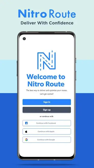
Nitro Route Planner
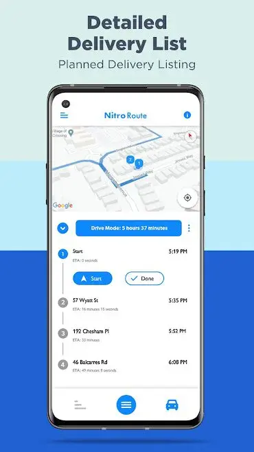
Nitro Route Planner app allows you to save yourself from all the struggles that a delivery driver faces on a daily basis to deliver some more items while saving some extra time. Users can view a map to get directions to any given location, and it shows the distance to the upcoming turn in metric units.
The app enables you to sign up by using email to save all your data about delivery routes on a cloud server to access it on other devices, and you can also restore the data from the cloud server in case of data deletion.
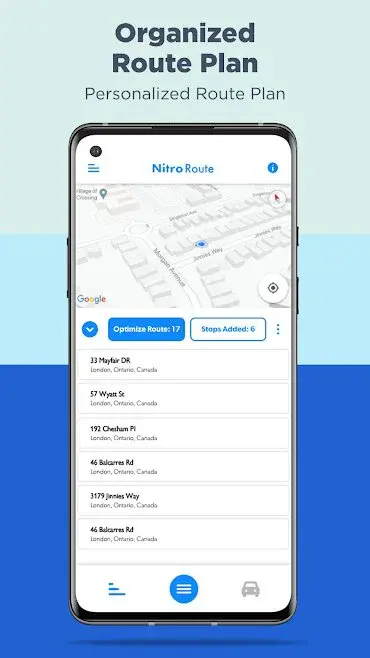
Nitro Route Planner app features the organization of all the delivery addresses on a route plan, and it shows the total number of addresses in each route with the street address of each destination. Users can view the route in the drive mode to get the estimated traveling time from one location to another.


Nitro Route Planner Alternatives
#1 Moovit

Moovit: Timing & Navigation for all Transit Types app allow users to keep track of all their public transport rides like bus, tram, metro train, and various other modes of transport. You can also request rides through various transit apps such as Uber, etc. to get to your office or any given location in no time.
Moovit: Train & Bus Times app enables users to enter the street address of your current location and the address of the destination to get the traveling time through all the available modes of transportation. You can create reports about stations and other places to share your ideas with the government.
Moovit: Navigation, Bus Tracker, Uber app features push notification alerts, so users don’t miss their train or bus and reach at their destination on time. You can download maps in PDF format to navigate through underground metro stations and subways without using an active internet connection.
#2 Funliday

Funliday – Travel planner, collaborative editing app enable you to create a complete plan for your trip by getting complete information of all the famous tourist and local attractions. Users can view the time required to travel to the next attraction from the previous attraction and the enjoying time at each attraction.
Funliday – The travel Planner app features the creation of sample trips so you can invite your friends and family members to discuss all the aspects of your trip without actually booking the trip in real-life. It shows the day-by-day schedule of the trip with the name of the day and the start time of the trip.
Funliday – Plan trips, Share memories app allow you to access a mini-map to measure the distance between any two given points as well as you can also view the exact location of the destination. Users can organize their visits to all attractions during their trip by using the drag and drop features.
#3 MyRoutes Route Planner Pro

MyRoutes Route Planner Pro app features trail planning, so cyclists, runners, hikers, and various other outdoor adventurers can follow a pre-selected path to have some more fun in the wild. You can delete all the distance and location markers from the map by tapping on the clear button.
The app allows users to upload a new adventure route to the database by entering the name, type of the route, settings, and a short description, as well as they can also add the map to a private list. You can send the GFX of a map with your fellow adventurers by using various social media apps.
MyRoutes Route Planner Pro app enables users to add distance markers to the map for automatic scaling, and it shows the total distance between the two given points in metric or imperial units. You can access the phone’s internal storage to import map files and open them with a single tap.
#4 TripIt

TripIt is an online platform that organizes all your travel plans in one place, specially made for those people who love traveling and want to explore the beauty of the world. You need to forward all your hotel, flights, and restaurant confirmation emails to TripIt mailbox, and the application automatically transforms your emails into the master itinerary for every trip, so all your plans are in one place.
After the confirmation, you can also make changes or edit your plans with ease. It does not just organize your travel plans, but also helps you during the travel such as recommended the nearby place, find the location, and the like.
Trip It app also offers lots of prominent features such as sync your travel plans with your calendar, receive real-time flight alerts, get fare refund notifications, share your plans with others, and enjoy exciting deals, etc.
The pro version of this app lets you find more options, such as hotel accommodations of your choice, ads-free atmosphere, and more. It has millions of users around the world who can use TripIt to enjoy the best traveling experience.
#5 LeadPlotter

LeadPlotter – Route Planner & Sales CRM app allows you to give a boost to your business by simply creating an extensive map for your delivery staff to help them in the effortless delivery of parcels. LeadPlotter Route & Sales CRM app enables you to view a map to take a look at all the marked locations on the map, and you can zoom in to the map to view streets in detail. Users can manage all the available account fields and can delete existing fields as well as can create new, fully filterable fields according to their needs.
LeadPlotter – Route Planner Sales Map CRM app features a profile section so you can enter your email address, phone number, website link, name, name of the receptionist, and other location data. Users can select any given area on the map to create a custom route by completing more deliveries in less time.
#6 Attlaz

Attlaz app enables users to receive fully personalized routes to their home, office, or all the other destinations while avoiding dense traffic to get to their destination while saving some extra time. You can send the route to your colleagues and other contacts to help them in reaching their destination.
Attlaz – Route Planner app features options to create a new route in a few simple steps, so you only need to pick up the addresses of the start and endpoints of the route. You can export maps to the internal storage of your mobile phone to view them in other apps.
Attlaz app allows users to enter the keyword or name of the location on the search bar by typing on the keyboard, or they can tap on the mic icon to convert their speech to text. You can add as many stops as you want in a single given route and can optimize the route by managing the number of stops.
#7 GPS Satellite – Live Earth Maps & Voice Navigation

GPS Satellite – Live Earth Maps & Voice Navigation is an app by Free App Valley that features speech to text conversion so you can search for the desired location on the map without having to type the address or the name of the location physically.
GPS Satellite app allows you to enter two addresses in the route creation section to measure the distance between the start and the endpoint of the journey as well as the exact time required to travel from start to end of the route. Users can find and save parking location before entering the area and can find the address by uploading the GPS location.
GPS Satellite – Live Earth Maps & Voice Navigation app enables you to access a built-in compass to track their current position’s direction and altitude. Users can view the coordinates of their current location in digress as well as can view the accurate time of sunset and sunrise.
#8 Bikemap

Bikemap – Your Cycling Map & GPS Navigation is a digital cycling companion that allows users to find new biking trails for mountain bike riding, street bike riding, cross bike riding, etc. You can download a map to the internal storage to navigate through the streets without using an active internet connection.
Bikemap app enables users to upload their current location on the map and enter the address of the destination to start cycling as well as they can also add as many stops as they want to the route to increase or decrease the traveling time. You can optimize the route finder to view routes according to the available type of bike.
Bikemap – Cycling Map & GPS app features street-by-street navigation with the duration of the traveling, current speed, total distance covered, distance left, time left to reach the destination, and the estimated arrival time at the destination.
#9 TouchTrails

TouchTrails app enables you to measure your exercise, running, and cardio activities by simply entering the start and the endpoint. Users can delete the route by tapping and selecting it, as well as can type the name of a location on the search bar to view it on the map.
TouchTrails – Route Planner, GPX Viewer/Editor app features a complete elevation profile of the recent running session so you can plan the next activities according to your fitness goals. The elevation profile shows the total gain in height, highest elevation during the trial, and the lowest elevation during the trial.
TouchTrails app allows you to draw the running trial on the map using your fingers, and you can change the color of the track lines to indicate different routes. Users can select the desired area on a map to download it, and it shows the total number of downloaded tiles at a glance.
#10 Hypr Route Planner

Hypr Route Planner app features options so users can add stops to their current trip while saving some extra time and money. You can start the navigation towards your destination by tapping on the map buttons to access the Google maps app.
The app allows users to access the built-in map to upload their current location, and they can tap on the edit button to start customizing route without much of a stretch. You can add a new location to the current route by tapping on the plus icon and entering the name of the location on the search bar.
Hypr Route Planner app enables users to sign in to their Google account to start the map creation process while on the go. You can tap on the optimized route button to view the street address of the location, duration to reach the destination, and the distance to the endpoint of the route.
#11 MyRoute Multi Stop Navigation

MyRoute Multi Stop Navigation app allows you to choose the desired navigation app and enter the address of your destination to start navigating right at your fingertips. Users can change the value of the arrival distance and measuring units from miles or kilometers.
MyRoute: Multi-stop route navigation app enables you to take a look at the distance of the endpoint of the address to save some extra fuel, time, and money by changing the route. Users can get an estimate of the time and fuel required to travel from the start point to the endpoint of the route.
MyRoute Multi Stop Navigation app features the addition of a large number of stops so you can visit more than one place on the same trip. Users can access the settings section to turn on the notification alerts to view the arrival and departure alerts right on the notification panel.
#12 Cycle Journey Planner
Cycle Journey Planner app enables users to access street maps of various cities and metropolitan areas right on their mobile phone screen in order to plan a route with the desired stops and other options. You can view the average cycling speed, maximum speed during the whole trip, total covered distance in meters, and the current cycling speed.
The app features options so users can select the desired city map from the home screen by tapping on a city’s name. You can edit the difficulty level of the desired tour and can turn on the option to avoid high hills while creating a cycle trip.
Cycle Journey Planner app allows users to access the tour planning, speedo saved, featured settings, and the profile section. You can enter both the address of start and endpoint as well as can select the option like cycle routes or trains to calculate the traveling details.
#13 MultiAddress

MultiAddress is a navigational app by Adam Wojtasik that features the creation of delivery so you can effortlessly visit as many addresses as you want without having to worry about the time. Users can make in-app purchases to upgrade their accounts from the shop section.
MultiAddress – multiple address route planner app allows you to select the desired route from the home screen to view the distance of all the addresses, and you can complete the visits by tapping on the Done button. Users can track their upgrade status from the shop section.
MultiAddress app enables you to access the tasks, add a new task, completed tasks, profile, sharing, and the settings section from the side panel with a single tap. It shows the total number of tasks, and users can enter the address of a location by searching on the map to add a new task.
#14 Badger Map

Badger Map – Route Planner for Sales app allows users to expand their delivery and courier business by simply creating sales routes and sending the desired route to the concerned delivery driver. You can make some last-minute changes to the delivery schedule.
Badger Map Route Planner Sales app enables users to optimize delivery routes for their employees, so they don’t have to drive far away to deliver the package to save some extra time. You can enter keywords such as the name of the company, location, and industry, etc.
Badger Map Routing for Field Sales app features swiping between accounts so users can create routes and share them through the desired account with a single tap. You can also enter the detail of each customer in each delivery route and can view the list of all the customers in various colors on the basis of the number of sales.
#15 Plan my Trip: Route Planner

Plan my Trip: Route Planner app enable you to get detailed information about all the important places of any given city from all around the globe. Users can find the shortest route between any two given points on the map to cut down the fuel costs while reaching their destination in no time.
Plan my Trip app features route finding so you can enter your location and can select the location of your destination to get a personalized traveling route. It shows routes for various traveling methods such as driving, public transport, cycling, walking, etc.
Plan my Trip: Route Planner app allow you to access the nearby places section to view the location of nearby banks, mosques, hospitals, universities, parks, fire stations, post offices, and various other places. Users can view the traveling distance to their destination in kilometers, and it also shows the time required to travel.
#16 Truck route planner
Truck route planner app features a built-in map so users can get the street address, longitude, latitude, and the coordinate to send them to your friends and family members through email. Users can measure the distance in metric units by creating two points on the map.
Truck route planner: car& truck route maps online app allows users to save the location and the route to a separate folder to view it later. You can access the compass to get accurate traveling directions.
Truck route planner app enables users to enter the address or the city name on the search bar to create a route, and users can zoom in the map by using their fingers to view the route in detail. You can view the traveling speed of your vehicle to keep track of fuel consumption and also can reduce the speed to cut down costs.
#17 Calimoto

Calimoto – Motorcycle Rides & Offline GPS app enable users to drop points or pins on the map to get a personalized map for their motorcycle trip with accurate details about the weather, condition of the track, and various other aspects. You can view the profile of the creator of each map to view all the other maps by the same creator.
Calimoto Motorcycle Routes app features details of trips of other motorcyclists with the total covered distance in kilometers, the direction of the trip, the start location, and the end location of the trip, etc.
Calimoto – Best Motorcycle Roads & GPS app allow users to keep track of their traveling with the current estimated height value, distance to the next turn, distance left, and the estimated time of arriving at the endpoint of the trip. You can view the reviews about a track by other users to get a better idea and can add your review to help them.
#18 Logistia Route Planner

Logistia Route Planner is a navigational app by Fespore IT that features visualization of all the delivery routes so you can assign deliveries to the desired delivery driver to cut down the labor and delivery costs of your company. Users can view the complete list of all the orders with the customer name, price, status of the order, delivery date, etc.
Logistia Route Planner – Local delivery & routing app allows you to access the options menu in order to apply driver filters to view routes accordingly as well as you can import orders from the internal storage to save some effort.
Logistia Route Planner app enables you to create and save a new order after viewing the summary of all the available orders with the shipping cost and any other hidden charges. Users can add their desired delivery time and can write a comment to give some suggestions.
#19 Probus

Probus is an app by Irina Petukhova that allows users to view the complete schedule of public transport buses by entering the name of the starting location, ending location of the journey, and the date of the traveling. You can enter the future dates of the traveling on the home screen to view the timings of buses.
The app enables users to access a built-in calendar to view their schedule of traveling through buses according to dates and days of the week. You can rate and review the app to help the team of developers in launching new features as well as to help other travelers.
Probus app features a live chat section so users can easily get help regarding the timings of the buses and various other issues. You can change the starting point and the destination of your journey at any given time to change your schedule.